I. Project construction content

(1)Detected by the competent network of about 140 kilometers above DN100. Including pipeline plane position, direction, depth, material, specification, embedding time, etc.; compiling and drawing integrated underground pipe network; establishing underground pipeline database; completing seamless connection with geographic information system.
(2)Establish a water supply pipe network database (including surveying and mapping results and digital archives); water supply network GIS design, system function development and system integration, system hardware configuration procurement, and the overall information construction of Linqing City Water Supply Co., Ltd. Establish a seamless connection with the GPS inspection system.
Ⅱ.Business introduction
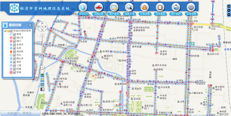
The pipe network geographic information system extracts and centrally transmits all kinds of basic data and business operation data to the database, exchanges information and communication, and comprehensively integrates the business information of the water company into an integrated data service. The platform realizes unified management, sharing and mining of data, and provides powerful tools and reliable basis for daily work such as pipe network data management and maintenance, pipe network information query and statistics, and pipe network emergency command and dispatch.
Ⅱ.System Features
(1)Establish a unified network information data center:
The organic integration of pipe network data and geographic information has changed the way traditional drawing data is stored, data storage is more standardized, and access is more rapid.
(2)Establish a complete pipe network data display center:
The data is based on the visual display of the map, accurately locates the target data, provides a customized search method and display method, and provides various display reports. Provide convenient display means for daily work.
(3)Establish a sound emergency decision-making system for water supply dispatch:
When an accident occurs, it can provide important support for emergency decision-making, and passively take the initiative to improve the speed of accident response and reduce accident losses.
Ⅳ.Functional description
(1)Spatial data management implementation methods are diverse, including data transformation, data reconstruction, data extraction, etc.
(2)The ability to integrate multiple spatial data enables the sharing and comprehensive utilization of spatial data.
(3)Analytical techniques for spatial data based on location and morphology of geographic objects.


